
One you won’t find on Google Maps. (Source: AWM)
At some point in your research you will want to locate a place with precision. Google Maps is a great resource but some names have changed since 1918, and Google will not always be able to help you with a trench map reference, or a colloquial name that was used only by the soldiers at the time.
Gazetteers
A gazetteer is, says Wikipedia, a geographical dictionary or directory, an important reference for information about places and place names. These gazetteers will help match historical to modern place names – try Wytschaete for example.
- GeoNames Search – National Geospatial-Intelligence Agency
- Getty Thesaurus of Geographic Names – The J. Paul Getty Trust
- Find a trench map reference – courtesy Bill Frost
Online maps
- Google Maps is the default and will answer many questions. StreetView allows you to explore many of the battlefields and back areas from home. Google Earth gives you a three-dimensional view of the terrain.
- OpenStreetMap is the free wiki world map. Because it is a community-generated map, it often has additional features marked, like WWI bunkers.
- Géoportail is the French government’s comprehensive web mapping service for France and its territories, great for identifying small villages like Flers from larger towns with the same name. Géoportail also offers historical data, including aerial photographs going back more than 50 years, the 18th-century Cassini maps and Napoléonic-era cadastres that can help identify camp boundaries in war diary maps. Géoportail is a powerful tool, and worth getting to know.
Campaign, battle & big picture maps
- The Official History of Australia in the War of 1914–1918 edited by Charles Bean has many useful maps of large and small scale, and they’re available online (although the maps are not necessarily scanned at their best). See also The Gallipoli map collection on the Australian War Memorial site.
- The recently published ANZACS on the Western Front: The Australian War Memorial Battlefield Guide by Peter Pedersen with Chris Roberts uses contemporary and modern photos to orient you in the landscape of France and Flanders and is highly recommended.
- Commonwealth Cemeteries of World War I offers a Google Earth visualisation of Commonwealth cemeteries, burial plots and memorials across the globe.
Trench maps
Detailed, up to date maps were needed for both attack and defence, and millions were printed during the First World War. Typically they show a base map with roads, towns and other important features overprinted with Allied and German trenches and a reference grid.
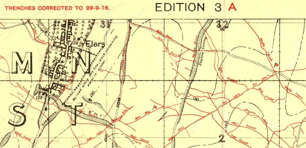
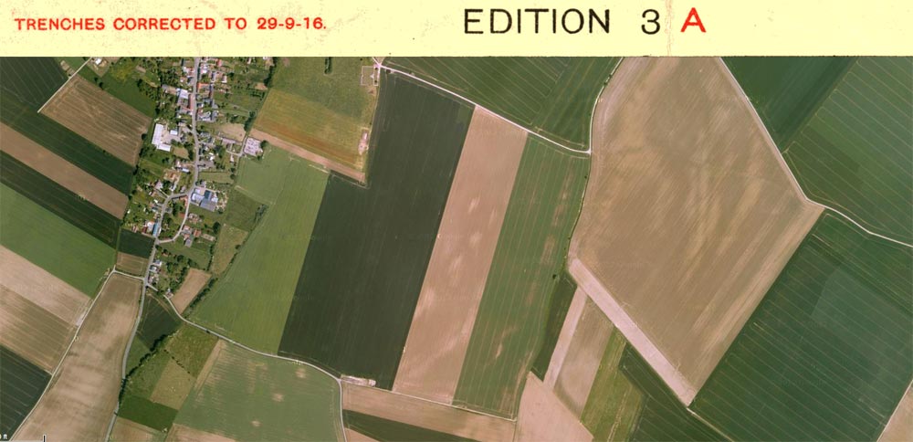
Allan Allsop’s diary records him being at 8th Field Ambulance posts at Needle Trench and Gun Alley to the right of Flers. They are marked with red flags in the trench map extract above, alongside an approximate modern view. (Source: LinesMan, Google Maps)
Reading a trench map reference
War diaries will frequently refer to positions on these maps with map references like “36A F.4.b.9.4” or “Sheet 28 NW.G.12b”. They are not hard to read once you’ve deciphered two or three.
- How to Read Map Reference Numbers – McMaster University
- Reading a British trench map – The Long, Long Trail
New Great War British Trench Map Coordinates Converter
Robert Warren of the Muninn Project has created an API to convert Western Front trench map coordinates to and from longitude and latitude. And he’s made available a web page that you can use to find coordinates on a modern map.
This is a boon for anyone working through a unit war diary, wanting to find quickly the locations and places referred to by the map coordinates. Read more on Warren’s blog post, Converting British Trench Map Coordinates.
A trench map gazetteer
Bill Frost has compiled an excellent resource to locate a relevant trench map:
Newcomers to the forum often ask where they can get a trench map that shows a specific location, such as Bethune or Bois de Ploegsteert. Often they don’t know whether it is in France or Belgium. Here is a resource I hope proves useful – a freely downloadable spreadsheet showing 4,500 regions, towns, woods or streams. Each has its latitude, longitude, link to Google Earth and trenchmap reference. There are also a handful of chateaus & farms. Once downloaded, it can be sorted or searched.
Finding trench maps to view or download
More difficult is finding the map, but there are free sources:
- WWI Aerial Photographs (all scales) & WWI Military Maps – McMaster University
- A selection of sketch and trench maps from British war diaries – The Long, Long Trail
New British First World War Trench Maps, 1915-1918 from the National Library of Scotland allows you to browse by map sheet and overlay trench maps on Google and Bing maps.
Remember also to look in unit war diaries as they often incorporate maps. Look up the chain of command for their diaries too.
There are also trench map collections for sale.
- LinesMan is ‘the most comprehensive interactive 1914-1918 Western Front trench map archive.’ It can also be used in the field with a GPS.
- British Trench map Atlas: The Western Front 1914-1918 offers 700+ trench maps from the UK National Archives.
The art and science of Great War mapping
If you’re interested in the evolution of mapping, and the development of technologies like aerial photography and sound ranging in the First World War, the following document is the most valuable primary source:
- Report on Survey on the Western Front, 1914–1918 – Published in 1920, HMSO. By Colonel E.M. Jack.